I have noted in other articles about my academic move from Vermillion, SD, to Salt Lake City, UT. It was the case of a small-town Kansas kid moving west to the mountains of his youthful dreams. How many times had he ogled at the advertisements in the back pages of “outdoor’ magazines promising a job as a “forest ranger” or maybe even a ”government trapper?” How many times during his high school and undergrad days had he applied for a summer position in one of the national forests---any job would do? But, as usual, he spent his hot Kansas summers working at his father’s gasoline station and/or driving a tractor for his uncle. But hey, it was money in the bank.
Now a journey to the mountains was “for real” and I (along with a new youthful bride) were off to follow the mountain men explorers, although as a geologist rather than a beaver trapper. There were so many new places with rocks and fossils and peaks and deserts that were absent in the Plains. What a fantastic time to be a geologist but also realizing that there was so much to learn. Those feelings are still with me today!
Early on in my University of Utah days one of my fellow grad students suggested a long Saturday field trip to the San Rafael Swell near Price, Utah. So off we go with rock hammers, lunch, cameras, and for me—a great deal of excitement. At that point in my life, I didn’t have the slightest idea of what the Swell was, nor what we would see on a field trip. All was new; most rockhounds can attest to this thrill building up as the week winds down for a Saturday field trip!
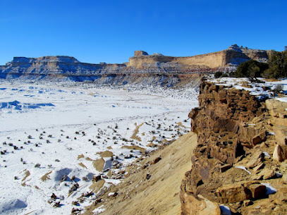
Cliffs of Cretaceous rocks forming a western boundary to the Swell.
After a main highway sojourn, we finally turned onto a gravel/dirt road and I became absolutely amazed at the sights. To the west were the towering blue to blue-gray cliffs of the Cretaceous Mancos Shale. These marine rocks were part of the Western Interior Seaway that once extended from the Arctic Ocean south to the Gulf of Mexico and from Utah through Kansas (in today’s geographic terminology). As we traversed down section into the Swell, I could recognize the older Cretaceous Cedar Mountain and Dakota/Naturita Formations, the Jurassic dinosaur-bearing Morrison Formation and then into the majestic red rocks of Jurassic, Triassic, and Permian age complete with deep canyons, high cliffs, and lookouts where you could gaze for tens of miles without seeing human habitation. While eating lunch on a large boulder in the lazy warm sun I think my spouse had an epiphany on why I wanted to become a professional geologist and work “in the West.” And so, she accompanied me almost every summer for 20 years as I hauled my undergrad students around the “West” to help me with research projects, or to direct grad students on their own projects. Just as I fell in love with the Black Hills during my South Dakota days, I fell head over heels for the Colorado Plateau and especially the San Rafael Swell.
Rocks to impress a flatlander and love forever.
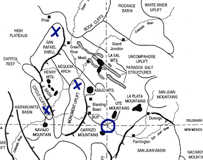
Geologically, the southwest quadrant of Utah, part of the Colorado Plateau Physiographic Province, is dominated by several small anticlinal uplifts and larger laccolitic peaks. By small, I mean the anticlines do not approach the size of time-related (Laramide Orogeny) mountain ranges such as the Uinta Range, but still extend tens of miles in length. The “big” anticlinal mountains expose Precambrian rocks in the center that usually form the high peaks. The “smaller” upwarps usually have rocks no older than Pennsylvanian in the center. However, there are some spectacular folds and “bent” rocks within these upwarps. The best-known upwarp features in Utah are the Monument Upwarp, the San Rafael Swell (a large anticlinal uplift with a steeply dipping and folded eastern margin termed the San Rafael Reef) and the Circle Cliffs Uplift (a north-south doubly-plunging anticline with a steeply dipping (almost vertical) eastern margin, the Waterpocket Fold). These large upwarps “were formed by tangential compressional forces that were episodically repeated throughout the Phanerozoic [post Precambrian] and most magnificently accentuated by Laramide and younger tectonism” (Stevenson, 2000).
|
Laramide anticlinal uplifts centered around Four Corners Region (X). Original source unknown but commonly attributed to Don Barrs. |
|
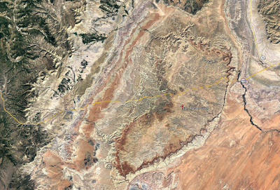
Google Earth© image of “bean-shaped” San Rafael Swell in Emery County, Utah. The San Rafael Reef (steeply dipping beds) is the “toothed” area in the southeast. To a small town flatlander like me, the scenery I saw that 1967 day in the Swell was almost overwhelming. I was swimming in sensory overload and could not quite contemplate what was going on. As a want-ta-be geologist I had a thousand questions and was thinking about a future dissertation project—and about blew my mind. The small knob was the site of the Rough Road Quarry in the Cedar Mountain Formation. See Eaton and Nelson in References Cited. Well, I never settled on a dissertation project in the Swell but later spent the better part of three years hunting for Cretaceous mammals in the Cedar Mountain Formation and supervising four MS students working on theses. My project turned out reasonably well as the Rough Road Quarry produced numerous small mammal, reptile, and “fish” specimens. This work was started when mammals were almost unknown in the Early Cretaceous rocks of the U.S. and before the famous Utahraptor discovery in the Cedar Mountain near Moab set off a massive paleontological hunt in the unit. About the same time as my work in the late 1980s-early1990s paleontologists from Weber State University and the University of Oklahoma hit the jackpot with several new quarries, and major finds of mammals, in the unit. As for me, I ventured over to the world of university administration. During those early years of my stay at the University of Utah all roads into the Swell were essentially graded native rock, sediment and “dirt.” I was stranded and “stuck” more than once when the bentonitic sediment became wet. Visitors were few and the camping and exploring were great and so for the following 20 years the Swell was our “go to” place to escape. I was especially drawn to the Cleveland-Lloyd Dinosaur Quarry where Jim Madsen, my good friend and research companion, spent most of his summer months.
The University of Utah scientists began studies on San Rafael Swell dinosaurs in the 1920s followed by paleontologists from Princeton University. In 1960 the University of Utah commenced a 5-year project with several cooperating schools under the administrative leadership of Dr. William Lee Stokes and field leadership of Madsen. In those days the quarry was protected from the elements by a corrugated roof structure with few other accommodations. Today the Quarry and a few surrounding acres have been designated as Jurassic National Monument and a new museum-like building has been constructed. Over the years, bones have been taken from the quarry representing at least 70 different animals and 11 species. Cast and original skeletons assembled from these bones are on display in over 60 museums worldwide. Cleveland-Lloyd Dinosaur Quarry in Jurassic National Monument. Public Domain photo by Richard M. Warnick. The Swell opened for travelers to catch sight of the fantastic scenery when I-70 in Utah was partially completed and opened as two lanes in late 1970. However, total construction and dedication was not completed until 1990. The Swell is still a rather uncrowded hunk of land perhaps best known by road warriors as the longest stretch of Interstate highway, 110 miles between Salina and Green River, without any urban development or services for visitors—fill up the gasoline tank before travel. I suppose most people traversing through the Swell, especially those in a hurry and those without an appreciation for desert scenery, might remember the gate to the eastern section. Here, I-70 cuts through the upturned rock known as the San Rafael Reef. It is an amazing bit of travel through Jurassic and Triassic rocks.
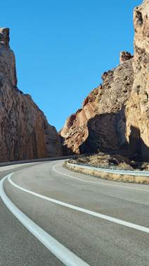
 Driving I-70 through the upturned rocks of the San Rafael Reef approaching from the east (lower two photos), and approaching from the west (upper photo). Rockhounding in the Swell is sort of a mixed bag. MinDat lists a total of 83 valid minerals (Type Localities for three uranium minerals) found in the San Rafael Swell Mining District, a fishhook shaped area covering the eastern and southern exposures. Research by thediggings dot com noted mines and prospects in the District: includes 5493 nearby claims—39 active and 5454 closed—and 183 nearby mines—49 occurrences, 28 prospects, and 106 producers. Virtually all mines and prospects were after uranium and/or vanadium from the Chinle Formation with perhaps a little copper thrown in, maybe a tad of zinc and lead. After World War II the need for uranium to fund the Atomic Energy Commission (AEC) projects created a large boom in the late 1940’s and 1950’s and brought thousands of prospectors, miners and merchants to Utah, including a ‘rags-to-riches” Texan by the name of Charlie Steen. His discovery, in 1952, of the Mi Vida (My Life) mine near Moab triggered a “uranium rush” to the Colorado Plateau that rivaled the fabled gold rushes of the 1800’s. School teachers, insurance brokers, used car salesmen, and shoe clerks around the nation converged on the Colorado Plateau to seek their fortune. Even a group of high school students staked forty claims and later sold them for $15,000. By the mid-1950s, almost six hundred producers on the Colorado Plateau were shipping uranium ore. Employment in the industry topped 8,000 workers in the mines and mills. Another bonanza in penny uranium stock established Salt Lake City as The Wall Street of Uranium. The AEC had turned the tap and caused a flood. By 1960 Utah was producing in excess of 6.5 million pounds of uranium; however, in 1964 the AEC decided to stop purchasing uranium and the bust cycle was on (Ringholz, 2009), although there have been a few minor boom cycles in the last 50 years.
I sort of refuse to touch most radioactive minerals and have never really been interested in collecting such, especially specimens containing any sort of uranium. In fact, my collecting habits in the Swell have been tied to fossils and various types of micro crystalline quartz with a few pieces of “petrified” wood thrown in. However, I have enjoyed taking a look at several of the abandoned uranium/vanadium mines but have never ventured near the mine entrances. I am quite claustrophobic and don’t want to take any chance of a poisonous gas leaking out. In other words, I could/would not work in the mining industry where underground journeys were required. I am certain this habit kept me from finding a plethora of nifty mineral specimens! The "old" bridge crossing the San Rafael River in the middle of the Swell. It was infamous for moaning and groaning and sagging whenever a car slowly crept from one bank to the other. A new ugly, concrete bridge, seen to the left, was offered as a replacement. Calf Mesa is a well know area in the northern part of the large San Rafael Mining District, not far from the "old bridge". The Rim of the Mesa is mostly composed of the Entrada Formation although small “slivers” of the overlying Curtis Formation may be present. Underlying the Entrada is the Chinle Formation that contains a sandstone/conglomeratic, channel-fill, unit variously referred to as the Shinarump Member or the Moss Back Member that are/were the major producers of uranium and vanadium in the San Rafael Swell. A cluster of mines along the side of the Mesa has produced 28 valid minerals according to MinDat. The best known of the Calf Mesa Mines is the Dexter #7. According MinDat the Mine, from 1950 through 1957, produced more than 500 tons of ore which averaged about 0.27 percent Uranium 308 and 0.05 percent Vanadium 205. Today the Mine is long abandoned; however, the large scattering of mine equipment, the ease of locating and accessing the mine (if you like to walk), and the chance of collecting rare to uncommon iron sulfate minerals such as butlerite, copiapite, coquimbite, krausite, melanterite, romerite, voltaite, and goldichite (the Type Locality) attracts a variety of specimen collectors. However, it now appears that rockhounds have company at Calf Mesa as ” Anfield Energy Inc., a uranium and vanadium mining company based in Vancouver, British Columbia, Canada, [Anfield purchased in late 2024 by Isoenergy Ltd.] has purchased a 100 percent interest in 26 unpatented mining claims of the Calf Mesa uranium project, located in Emery County” (Salt Lake Business Journal, 14 January 2023). The rim of Calf Mesa. Photo courtesy of Dennis Udink, Price, UT
Probably the most collectable mineral from the Dexter #7 is the uncommon, hydrated, iron sulfate coquimbite: AlFe3(SO4)6(H2O)12·6H2O. Crystals are colorless to lavender to purple to pink to greenish to yellowish---often in the same specimen. They usually are short prismatic with small unequal pyramidal faces. Crystals are transparent, sub-vitreous to resinous and quite soft at 2.0-2.5 (Mohs), brittle with a sub0conchoidal fracture and a whit streak. They would, at first, be tough to identify (for an old plugger like me) unless one knew the collecting locality—arid region as a secondary mineral in oxidized sulfide deposits. It also may form in volcanic fumaroles and/or in underground mine fires. Whatever the case, once one sees the crystals the identity seems to stick in your mind. Clear to light purple or lavender sub-millimeter crystals of coquimbite (color varies across specimen). Also present are the hydrated iron sulfates halotrichite (H white fibrous encrustations), voltaite (V dark green to mostly "black"), romerite (R brownish orange), and a yellow unknown mineral, probably copiapite (?C) but possibly some goldichite? These latter minerals are even smaller than the coquimbite and tough to identify. Searching for fossils in the mudstone outcrops of the Cedar Mountain Formation. Take your canteen and a snack and a Brunton. There is no shortage of water in the desert but exactly the right amount , a perfect ratio of water to rock, water to sand, insuring that wide free open, generous spacing among plants and animals, homes and towns and cities, which makes the arid West so different from any other part of the nation. Edward Abbey REFERENCES CITED Ringholz, R. C., 2009, Utah’s Uranium Boom in Beehive 16, Utah History to Go: http://historytogo.utah.gov/ *Going up the country is the title of a song by Canned Heat |
|
OF INTEREST |
Pomes, Michael L., "Stratigraphy, Paleontology and Paleobiogeography of Lower Vertebrates from the Cedar Mountain Formation (Lower Cretaceous), Emery County, Utah" (1988). Master's Thesis.
Conley, Steven J., "Stratigraphy and Depositional Environment of the Buckhorn Conglomerate Member of the Cedar Mountain Formation (Lower Cretaceous), Central Utah" (1986). Master's Thesis.
Crooks, Deborah M., "Petrology and Stratigraphy of the Morrison (Upper Jurassic) and Cedar Mountain (Lower Cretaceous) Formations, Emery County, Utah" (1986). Master's Thesis..
Hunter, David A., “Stratigraphy, Sedimentation, and Paleoenvironment of the Cedar Mountain Formation and the Dakota Sandstone (Cretaceous) in West-Central Emery County, Utah” (1990). Master's Thesis.
Nelson, M. E., and Crooks, D. M., 1987, Stratigraphy and paleontology of the Cedar Mountain Formation (Lower Cretaceous), eastern Emery County, Utah, in Averett, W. R., editor, Paleontology of the Dinosaur Triangle--guidebook for 1987 field trip: Grand Junction, Colorado, Museum of Western Colorado, p. 55-63
Eaton, J.G. & Nelson, M.E. 1991. Multituberculate mammals from the lower Cretaceous Cedar Mountain Formation, San Rafael Swell, Utah. Contributions to Geology, University of Wyoming, 20:1-12.


No comments:
Post a Comment