Tuesday, March 29, 2011

LOWER COLORADO RIVER TRENCH

PARKER DAM WAS BUILT AT A NARROW POINT IN THE VOLCANIC ROCKS

COLORADO RIVER TRENCH AT PARKER STRIP
 Most people in Colorado are probably unaware that the Arizona-California border is the Colorado River where numerous dams back up large lakes.  Arizonians refer to the area as the West Coast.  Starting  near Las Vegas with Lake Mead and Hoover Dam, the river has cut several deep canyons on the way south to Yuma, AZ and ultimately to its delta in the Gulf of California.  At times in the recent past the river actually emptied into the Salton Sea to the west of the current trench, an area created by faulting associated with the San Andreas Fault.  Now the river does not actually reach the Gulf as water is diverted off for irrigation and culinary use, evaporation rates are high, and the delta has blocked the channel.

Lake Mohave, about 65 miles in length, is downstream from Hoover Dam and behind Davis Dam. Parker Dam backs up Lake Havasu for 45 miles and is the source for both southern California drinking water (Colorado River Aqueduct) and the Phoenix metro area (Central Arizona Project).  Following those dams are the Palo Verde and Imperial dams.

I was amazed that the river near Parker, Arizona, (about midway on the border) is crystal clear and quite deep.  Geologists still are uncertain about the exact age of the lower Colorado River and the formation of the Grand Canyon (you will see figures ranging from 65 Ma to about 5 Ma).  What is known is that the river turns south near Vegas, cuts through mountain ranges, creates some fairly deep canyons, and pretty much runs in a straight line to the Gulf.  The path was at least partially determined by a series of faults and down-dropped basins here in the Basin and Range Physiographic Province.

At one time geologists believed the Gulf of California extended north nearly to Las Vegas and that the Colorado River simply keep cutting and following its retreat to the current location.  The evidence for this was the late Tertiary Bouse Formation, which in its lower reaches contains marine invertebrates.

Jon Spencer and Philip Pearthree of the Arizona Geological Survey have produced a great story of the Colorado River evolution in the Winter 2005 edition of Arizona Geology (http://www.azgs.state.az.us/), and the following summary is from that article:  Geologists now believe that the Bouse Formation was deposited by the Colorado River in a series of lakes that filled with river water and spilled over, eventually linking the river with the Gulf of California.  At the mouth of the Grand Canyon, the Colorado River first arrived less than 6 million years ago. Along the course of the lower Colorado River, it appears that all of the Bouse Formation was deposited between 5.5 and 5.3 million years ago and Colorado River sands arrived in the Salton Trough less than two hundred thousand years after deep flooding of Mohave Valley. The influx of Colorado River water and sediment at this time marks the inception of the modern Colorado River.  The modern Grand Canyon began with spillover of a very large lake in northeastern Arizona and rapid incision of the lake outflow point about 5.5 million years ago.

As for the marine invertebrates, recent studies show that evaporation in the southernmost lake as it was filling with river water (the only location for the fossils) could have elevated the salinity to sea-water levels.  Most likely birds transported the initial organisms to the inland waters.

I have been camped here at Buckskin State Park on the “Parker Strip” for a couple of weeks and have been exploring the geology.  It is complex, especially for a short-time visitor like me.  The rocks range in age from Precambrian crystalline to Paleozoic limestones to huge amounts of Tertiary volcanics to the sedimentary Bouse Formation and other basin-fill sediments to Quaternary gravels.  There are the lower plates rocks and the upper plate rocks and the detachment faults and the normal faults and the thousands of feet of sediments associated with the river that fill all of these paleovalleys along with the overlying terrace deposits.  It is a “jumbled mess” and I certainly appreciate the skill of the mapping geologists.  

mike
THE PINNACLE OF TOURIST SLEAZE--LONDON BRIDGE


VOLCANIC AGGLOMERATE

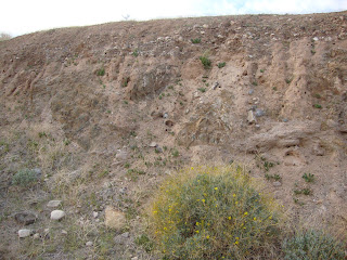
BASIN FILL SEDIMENTS AND SEDIMENTARY ROCKS

VIEW FROM THE EASY CHAIR

AT SOME LOCALITIES SAND HAS BLOWN FROM THE RIVER BED AND SANDBARS (PRE-DAM DAYS) AND CREATED DUNE FIELDS

Monday, March 28, 2011

BUCKET LIST FOR KIDS


The magazine Budget Travel had an interesting story about 10 places every kid should visit.  Since CSMS has such an active Pebble Pups and Juniors programs I took a great deal of interest in list.  I wondered “how many” of these sites could a Pebble Pup visit and learn something about geology?  So, here is their list with some personal comments.

THE GRAND CANYON-AZ.: a good choice (but how could anyone pass up this feature on a “list”).  The kids would pick up “lots of” ideas about sedimentary rocks, geomorphology, geologic time, canyon cutting etc.  Even a short hike down the trail would help the students better understand geology.

THE NATIONAL MALL-D.C.: well, not many outcrops but the kids could spend hours, or days, in the Smithsonian Museum of natural History.  If they were traveling with an adult with some geological knowledge, a good project would be looking at all of the monuments.  Remember the Lincoln memorial is carved from a single piece of Colorado Yule Marble.

REDWOOD NATIONAL PARK-CA.:  the big trees are always impressive.  The interesting part comes from being able to observe the ecology of marine tide pools.  The geological part is where the budding paleontologists can examine ancient rocks that contain fossil endemic to tide pools.

ELLIS ISLAND-NY:  Everyone needs to think about their ancestors.  The kids need a dinosaur fix?  For a great geological experience hit the American Museum of Natural History.

NIAGARA FALLS-NY: A great place for geology where one may examine stream action, downcutting, and waterfall formation all in one place.  They also could learn the “Niagara Escarpment” is found all over the Midwest.

YELLOWSTONE NATIONAL PARK-WY, ID, MT: Now, this has to be the geological hotspot of the nation.  A Pebble Pub could spend days at Yellowstone studying the geology.  The 3,472-square-mile park is home to more geothermal features (geysers, hot springs, mud spots) than any place on earth.

COLONIAL WILLIAMSBURG-VA: OK, this one stumps me; the geology is a little short.  Maybe could study the Appalachian Mountains.  Been there, was not overly impressed (although I am a history buff).

CRATERS OF THE MOON NATIONAL MONUMENT AND PRESERVE-ID:  Back to geology.  What a wonderful place to observe fairly modern volcanism (in the few thousands of years old).  I especially liked the lava tubes. 

 INDEPENDENCE HALL-PA:  A really good geological project here is studying the weathering rates on old tombstones.  You have the death dates, now identify the type of rock and all will agree that marble is pretty but does not last as long as granite.

ALCATRAZ ISLAND-CA:  Interesting choice from the editors but I suppose kids would enjoy it.  Place to study mountain building and plate tectonics but need to do homework before arrival. The ferry boat ride to the island is nice but...

So, I would leave out Alcatraz and substitute Yosemite National Park.  Substitute Rocky Mountain Park for Independence Hall and Badlands National Park for Colonial Williamsburg.  Ellis Island is OK if you make certain to visit the American Museum.  Otherwise take a trip north to Acadia National Park.

In my opinion, the best place for a kid to see is the inside of a tent at any locality in the Colorado Mountains!  Take them somewhere where they can pound on rocks and pick up some colorful chert—hook them while young.  Just take them.

What are your choices?  Leave a comment or drop me an email.

mike

Thursday, March 24, 2011

CIENEGA MINING DISTRICT

THE VOLCANIC ROCKS OF THE BUCKSKIN MOUNTAINS CROP OUT AT BUCKSKIN STATE PARK AND CROSS  THE COLORADO RIVER INTO CALIFORNIA AS THE WHIPPLE MOUNTAINS.

The Buckskin Mountains lie northeast of Parker, Arizona, with the range extending to the Colorado River, and in fact crossing the river to California where they are known as the Whipple Mountains.  Parker is about 28 miles south of Lake Havasu City and about 50 miles north of Blythe, CA.  The Buckskins are part of the Basin and Range Physiographic Province and related to extensional tectonics (as opposed to compressional tectonics as seen in the Colorado Front Range).  The range also displays the Buckskin-Rawhide Detachment Fault, a large, very low angle (sub horizontal) normal fault. The upper plate, or hanging wall, rocks consist of tilted syntectonic (deposited at time of uplift), mid-Tertiary sedimentary and volcanic units and deformed and metamorphosed Mesozoic and Paleozoic sedimentary and volcanic units. The lower plate, or footwall, is composed of metamorphosed crystalline and metasedimentary (sedimentary rocks changed because of metamorphism) units (Hawkins, 2010).  The geology seems quite complex, at least to me, and it is difficult to understand the mechanisms associated with mineralization!

A large mining district, the Cienega, lies within the Buckskins, and is described as a Cu-Au-Ag-Pb-Hg-W-Ba mining area (Hawkins, 2010).  The major target was (and is?) copper; however, significant amounts of gold and silver have been produced in past years (Scott, 1989). These deposits have produced, in total, about 52 million pounds of copper 15,500 ounces of gold, and a few hundred ounces of silver (Keith and others, 1983).

 Mineral deposits are widely distributed in the Cienega District and most occur along, or within a few feet, of the detachment fault, or along the other numerous small scale normal faults.  In hiking around the area I have seen mines located in basalt, in vuggy, almost cave-like limestone (partially metamorphosed), along breccias zones in various units,  along massive quartz veins, and in metamorphosed crystalline rocks.  Interesting minerals I noted included crystalline calcite, barite, chrysocolla, and specular hematite.  I was looking for fluorite, azurite and malachite---but, no luck.
REFERENCES CITED
Hawkins, W., 2010, Geological Report on eagle Nest Mining Claims, La Paz County, Arizona, United States: privately printed for Converge Global. Inc., Toronto, Ontario.

Keith, S.B., Gest, D.E., DeWitt, Ed, Woode Toll, Netta, and Everson, B.A., 1983, Metallic Mineral Districts and Production in Arizona:
Arizona Bureau of Geology and Mineral Technology Bulletin 194.

Scott, D. C., 1989, Mineral Investigation of the Gibraltar Mountain Wilderness Study Area (AZ-050-O12), La Paz County Arizona: U. S. department of the Interior, MLA 18-89..

mike 

OLD MINE ADIT FOLLOWS BRECCIA AND FAULT ZONES IN PALEOZOIC LIMESTONE. NOTE RECRYSTALLIZED ZONE OF PURE WHITE CALCITE.

MINE ADIT INTO VUGGY PALEOZOIC LIMESTONE.

MINE ADIT FOLLOWS BRECCIA AND FAULT ZONES IN TERTIARY VOLCANICS.

LARGE PIECES OF CRYSTALLINE BARITE ARE COMMON IN UPPER PLATE VOLCANIC ROCKS.
LARGE SCALE COPPER MINING IN PRECAMBRIAN GNEISS.
MAGENTA BLOOMS OF BEAVERTAIL CACTUS LIGHT UP THE DESERT.

Wednesday, March 9, 2011

A HOHOKAM VILLAGE

WHO TOOK A BITE?

Catalina State Park, immediately north of Tucson, contains a well- preserved Hohokam village situated at the edge of the Santa Catalina Mountains.  A small hike will lead the visitor to a cultural site that contains a variety of ruins.  Perhaps the most interesting is a “ball field” where evidence points to some sort of a game placed with a ball.  Archaeologists believe the balls were made from “natural” rubber found in a perennial shrubby plant called Guayule (a composite [daisy family],  Parthenium argentatum).  The plant is native to deserts of south Texas and northern Mexico but could have been cultivated by the Hohokam in Arizona, or perhaps was acquired by trade.  It is my understanding that Guayule balls were also used by ball playing individuals of the Mayan Civilization.  Today there is some manufacture of Guayule gloves as a replacement for “latex”.

The archaeologists believe the village held about 300 individuals, many of whom lived within a walled (perhaps six feet) complex.  Remains of individual dwellings may be observed in the village and several “trash” piles have been excavated.  Visitors may be lucky enough, as I was, to see small pieces of red-colored pottery lying around.

The Hohokam were farmers and grew squash, maize and beans along Sutherland Wash and Canyon del Oro below the village site.  Most likely they also made use of seeds of local plants such as pigweed, the grasses, and others.

The name Romero comes from a later settler, Francisco Romero, who ranched the area in the 1800’s.

As for the chunk out of the prickly pear--my guess is javelina as their tracks are abundant.


mike
REMAINS OF THE VILLAGE WALL, AT ONE TIME ~SIX FEET IN HEIGHT.


THE HOMES; NOT MUCH LEFT
THE ROMERO RANCH CA. 1850.

Tuesday, March 8, 2011

BASALT AT PICACHO PEAK


HOMELAND OF THE HOHOKAM CULTURE.  Map courtesy of Wikipedia.

The rocks around Phoenix and Tucson, Arizona, contain numerous “artifacts” that point to the presence of an archaeological culture known as the Hohokam.  Residents in my home state of Colorado are perhaps most familiar with another group, the Ancestral Puebloans (commonly called Anasazi), an ancient Native American culture centered on the present-day Four Corners region.  However, in this part of Arizona the Hohokam reign supreme.  Like the Anasazi, little is known of the Hohokam descendants.  What we do know is that the Hohokam were very successful in their endeavors.  They built the Great House, now partially preserved at Casa Grande National Monument (see previous blog), and left behind untold numbers of petroglyphs on rock outcrops.  Vestiges of their extensive irrigation canals may be found as these agrarians farmed fields of cotton, squash, maize and beans.  They seemed to have occupied the areas along the Santa Cruz, Gila, and Salt Rivers from about AD 0 to ~1450.

While hiking in some of the smaller basalt outcrops near Picacho Peak (see previous blog) I came across some quite interesting features in the rocks.  These were circular in nature, perhaps four to five inches in diameter, and ranged in depth up to 10 inches.  The structures obviously were made by “people” and were most common near the entrance to small caves.  They are bedrock mortars, or morteros, where members of the Hohokam Culture ground mesquite beans for use as food.  They seem identical to features found at Pima County’s Los Morteros Conservation Area (Arizona) and Indian Grinding Rock State Historical Park.  This latter site, in the foothills of California’s Sierra Nevada Mountains, is a limestone locality where the local Native American population ground acorns. 

At any rate, the sight of these structures was a serendipitous moment and made me pause to reflect on the human history of the Sonoran Desert.  I could just picture in my mind a group of people grinding away and experiencing a social interaction, perhaps yelling at small children to get off the cliffs and watch out for snakes, and talking about the weather.  It was a pleasant thought. 

mike
MORTEROS NEAR PICACHO PEAK.


MORTEROS NEAR MOUTH OF SMALL CAVE.