Friday, October 7, 2016

CUSTER, THE BLACK HILLS AND GOLD


As I write this small posting in late September 2016 while camped near Spearfish and later in Custer State Park in western South Dakota, I am reminded that George Armstrong Custer seems always present here in the Black Hills.  Custer left behind the name of a town, a mountain peak, city streets and numerous motels, cafes, bars—you name it and Custer’s name will be affixed at some location in the Hills.  Of course he also left behind the beginning of the end for a large group of Native Americans who were soon to lose their ancestral hunting grounds and their nomadic way of life.  There seems no middle ground here in the west for Custer—like him for opening the Black Hills to mining and settlement or despise him for destroying the local population of Native Americans.  Not so much killing the Natives in firefights, but in opening the Hills to settlement which resulted in the resettlement of the Natives and their loss of a huge hunk of land.  The beginning of the end started with Custer’s expedition to the Hills in 1874 and the end came only two years later at the Battle of the Greasy Grass (AKA Battle of the Little Bighorn or Custer’s Last Stand).  Literally hundreds of books and articles have been written about Custer in the West and readers have their choice of authors.  Even today there are new tomes being published that win major awards.  It is tough for me to understand how new information seems to appear and therefore offers authors a chance for different interpretations. 

At any rate, I am interested in the rocks and minerals that seem associated with the Custer expedition of 1874.  Thanks to authors like Ernest Grafe and Paul Horsted (2002), campsites and trails covered by the Expedition are well known and one can follow along the entire Black Hills’ route if desired.  Like many geologists and rockhounds I am greatly interested in the area around Custer City, the site of his “gold discovery.”


Lt. Col. George A. Custer was a Civil War hero (at least to the “North”) and at age 25 received the rank of Brevet Major General, and accolades poured in from the press for the “Boy General.”  At the conclusion of the War Custer remained in the U.S. Army and in 1866 was awarded the rank of lieutenant-colonel and assigned to a new regiment, the Seventh Cavalry.  Most/all of the regiment referred to him as General Custer.
 
Most Army officers thought the slaughter of Buffalo by meat and hide hunters, settlers, miners, etc. would signal the end of the nomadic Native Americans.
It was hard for army officers to advance in rank after the war and certainly “reconstruction duty” in one of the former Confederate states was not a great stepping stone.  Custer viewed himself as a frontiersman and pathfinder and yearned to do battle with Native Americans occupying much of the Plains States, especially the loose confederation of the various Lakota bands (mostly Oglala and Hunkpapa), the Northern Cheyenne and the Arapaho.  Therefore, Custer was instrumental in convincing General Philip Sheridan, Commander of the Division of the Missouri and General Alfred Terry, Commander of the Department of Dakota, that a military reconnaissance of the Black Hills of the Dakota Territory was a necessity.  All three officers wanted to subdue, by whatever means (such as firefights, slaughtering the Buffalo [Bison] herds, etc.), the Native Americans occupying the Hills and the Powder River Basin to the west; however, an unpublicized argument was to confirm the presence of minerals rumored to exist in the Black Hills.  President Grant then approved the expedition since after the Financial Panic of 1873 the country needed new resources such as gold and timber, and any gold/mineral rush to the hills would also provide “jobs” for the many unemployed men (and a few women). 

So, off Custer went on July 2, 1974, from Fort Abraham Lincoln across the Missouri River from Bismarck, North Dakota, with somewhere close to 1200 men.  Besides members of  10 companies of his 7th Calvary (including a 16 piece band), the group included ~110 wagons and accompanying teamsters, about 300 head of cattle for food in case the hunters could not produce game, a medical staff, several newspaper correspondents, the experienced miners Horatio Ross and William McKay (perhaps disguised as teamsters), several Native American Scouts, at least two of Custer’s staghounds, extra horses and mules, Chief Engineer Captain William Ludlow and his assistant (who produced wonderful maps), and Scientist George Bird Grinnell, a graduate student at Yale who later became a famous anthropologist, naturalist and writer, assigned to describe the flora and fauna.  Grinnell had three assistants: 1) Newton H. Winchell later became the Director of the Minnesota State Geological Survey and authored the six volume treatise entitled The Geology of Minnesota; 2) Luther North, a jack-of-all-trades best remembered for leading a group of Pawnee Scouts, along with his brother Frank, helping protect the Union Pacific Railroad and later business partners with William (Buffalo Bill) Cody); and 3) A.B. Donaldson, a botanist and newspaper “man” from Minnesota.  William Illingworth was the Expedition’s photographer who evidently was hired by Ludlow to provide photos for the U.S. Army.  The Expedition also included  at least one woman, a former slave known as Aunt Sally who cooked for Sulter John Smith.
  
The Expedition passed very close to Sundance Mountain on on July 22.  The isolated peak is a Tertiary laccolith described in a Post on Dec. 17, 2013.    
The botanist A.B. Donaldson also wrote dispatches for the St. Paul Pioneer.  Thanks to Hollis at www.plantsandrocks.blogspot.com  for sharing this article from South Dakota Historical Collections, Volume VII, 1914.
The initial part of the trip through western North Dakota and northern Wyoming was hot and dry with alkaline water but the Expedition reached the northwestern outlier of the Black Hills (Bear Lodge Mountains near present Sundance, Wyoming) around July 20.  On July 25 they crossed the Wyoming-South Dakota state line and entered the Black Hills proper from the Northwest.
Perhaps the Expedition knew they entered South Dakota by spotting a "state line" marker!
In the central part of the Hills the Expedition, or at least the photographer, termed these rocks the Organ Pipe Range.  Today they are known as The Needles and are part of Custer State Park situated north of Custer City.
After spending several days traversing the center of the Hills (reaching the Needles-Harney Peak at the end of July) area the Expedition reached the area a few miles east of Custer at a locality termed Agnes Park and “Permanent Camp.”   
 
Calamity Peak and the valley of French Creek near where Custer established his "Permanent Camp."  This scenic locality is located a few miles east of Custer City and is now on private land, but bisected by US 16A (heading east towards Custer State Park).  Gold was "discovered" in the foreground by miners Ross and McKay.  It was given the name Golden Park 

Custer's "Permanent Camp" near Golden Park in the valley of French Creek.  This photograph is a part of the Illingworth collection and the print is scattered across the Internet without much copyright information.  However, Grafe and Horsted (2002) give credit to the Minnelusa Pioneer Museum.

The miners of the Expedition, Ross and McKay, had been looking for minerals, especially gold, during the last few days.  It seems they found a few flakes near what is now Custer City and additional flakes and tiny nuggets along French Creek that runs through the "Permanent Camp" (known as Custer’s Gulch).  Most of the gold found along French Creek came from prospectors digging a hole along the stream through the gravel and preferably down to bedrock.  They then panned the gravel and sand lying on the bedrock surface and removed the tiny flakes.  Altogether it was not a great find; however, the tiny bits of metal certainly caused “gold fever” among the members of the Expedition as noted by a reporter for the Inter-Ocean (as reported in Grafe and Horsted (2002):  At daybreak there was a crowd around the ‘diggins,’ with every conceivable accoutrement.  Shovels and spades, picks, axes, tent-pins, pot hooks, bowie knives, mess pans, kettles, plates, platters, tin cups, and everything within reach that could either lift dirt or hold it was put in service by the worshippers of that gold, gold…Officers and privates, mule whackers and scientists, all met on a common level, and the great equalizer was that insignificant yellow dust. 

On August 3 Custer, not wanting to wait with the news of “gold in the Black Hills” until the Expedition returned to Ft. Lincoln, sent scout Charley Reynolds with a dispatch to Ft. Laramie in east-central Wyoming.  In glowing terms Custer over-exaggerated the gold discovery knowing full well that a rush would soon begin to the Black Hills! 

On August 5, 1874, 21 claim-holders from the Expedition formed the District No. 1, Custer Park Mining Company, Custer’s Gulch, Black Hills, D.T. Aug. 5, 1874.  The discovery claim belonged to miner Ross while one of the other claimants was Sarah Campbell (Aunt Sally who held title to “No. 7 below Discovery”).  In reality, very few of the claim owners ever returned to the Black Hills, although historical records point out that miner Ross and Aunt Sally did live out their days in the Black Hills; neither became wealthy from the gold along French Creek.
 
Bear Butte near where the Expedition camped after leaving the Hills.  The Butte is an Eocene laccolith.  See POST on June 12, 2012.
The Expedition left the Custer City area with dreams of gold and headed north leaving the Hills in mid-August at a locality known as Custer’s Gap along Boxelder Creek north of Rapid City.  Either good work by the scouts or sheer luck allowed the Expedition to “discover” the gap through the upturned sedimentary rocks that allowed movement onto the Plains.  Near Bear Butte the Expedition camped for a couple of days to retrofit the wagons and then had a rather uneventful trip back to Ft. Lincoln arriving July 30th.
The Expedition returning to Ft. Lincoln.  The Illingworth photo is often listed as the group leaving the Fort.  However, Grafe and Horstead (2002) noted that several wagons had stacks of elk horns picked up in the Hills indicating a return trip!  Grafe and Horstead also attributed the photo to the Minnelusa Pioneer Museum. 
By 1876 downtown Custer City was booming.  Photo
Rlevse private collection, Public Domain, https://commons.wikimedia.org/w/index.php?curid=4030996
The Laramie Treaty of 1868 had awarded the Black Hills to the local Native Americans and forbid settlement by “outsiders.”  Custer left the Hills in summer 1874 but by December of that year the gold-seeking Gordon Party (28 persons) from Iowa evaded Army patrols and built a stockade near Custer’s Permanent Camp.  The group was evicted by the Army in spring 1875 but the floodgate had cracked open and by the fall thousands of potential miners were camping in Dakota Territory and trying to “sneak into” the Hills; some were successful while others were killed by Native Americans or turned back by Army patrols.  On November 3, President U.S. Grant decided the Army would no longer patrol and turn back the settlers and the “rush” was in full force and hostilities with Native Americans became a common occurrence.  This brings us to June 25, 1876, and completes the journey to the end.  Certainly hostilities with Native Americans continued for another year; however, the two-year interval between Custer’s arrival in the Black Hills in summer 1874 and his demise in summer 1876 was the journey to the end.

What about the gold near Custer City?  Did it ever produce in “paying amounts”? Gold mining in the Custer area was never really very successful although many cubic yards of soil and gravel were turned over and panned or sluiced for the metal.  Placer gold is never as lucrative as lode gold and miners never really found the source of the flakes and small nuggets retrieved from the Custer area.  Most likely the source is “upstream” somewhere near Rochford, perhaps waiting for discovery.  Or perhaps the lode rock was eroded away!
Two small flakes of gold panned from French Creek.  The largest is ~3 mm.
Flakes of gold can be panned, with hard work, from many streams in the Black Hills.  And, one runs into claim markers at numerous localities.  However, none of the placer deposits seem more than recreational opportunities, but—hope springs eternal.
Lower French Creek southeast of Custer runs clear and scenic today.  However, in looking carefully one can observe areas where the gravel was 'dug up' and panned or sluiced.  The small flake above is from lower French Creek.
As for my panning attempts, I have a grand total of two flakes from French Creek.  However, I nether dug down to bedrock nor worked very hard! I just wanted to see if the early miners left a small tidbit for an ole geologist.  

REFERENCES CITED

Grafe, E. and P. Horsted, 2002, Exploring with Custer; The 1874 Black Hills Expedition: Golden valley Press, Custer, SD.  

Wednesday, September 21, 2016

BLACK HILLS: HOMESTAKE GOLD AND SCRIPOPHILY

In my last posting, a somewhat loquacious article, I described a small piece of native silver collected from the famous Homestake Mine in Lead, South Dakota.  Crystalline silver of any sort is rather rare in rocks of the Black Hills, including the Homestake.  My specimen was collected many decades ago and originally was in the collection of Carroll “Shorty” Withers but later was obtained by Willard Wulff; both gentlemen are famous Colorado micromounters.  Since then I have looked for specimens of Homestake gold; however, two items have held up my search: 1) most of the gold mined from the Homestake, especially in recent decades, was intimately tied up with the parent rock; and 2) the few specimens of “free gold” that I have seen are really, really expensive and often are marked “not for sale.”
So, where was an ole guy like me to find Homestake gold?  Well, believe it or not I was able to purchase several small flakes at the Sanford Museum overlooking the big open pit. According to a Certificate of Authenticity, when the South Mill at Homestake was being decommissioned in 2002, flakes of gold (67 total ounces) were discovered in the bottom of a concrete ditch that was previously used to transfer the ore slurry within the mill.  The surface of these flakes resemble nuggets; however, they were flattened in the stamp mills before taking a ride in the ditch.  Somewhere along the line these flakes were trapped in ditch crevices and Homestake believed the gold was mined as early as 1920.  Now, that is an interesting story, at least to me, but I now have some gold from the Homestake! 
Gold nuggets flattened by the stamp mill at the Homestake Mine.  Width FOV ~1.5 cm.
Up until a few years ago when I met a scripophilist, I really did not understand that a large cadre of people collected stock and bond certificates, especially those associated with western mining companies and railroads.  I actually had a couple of stock certificates stuck away in my cabinet of natural curiosities—picked up at garage sales decades ago.  I simply liked the engraving on the certificates, and the fact that both were associated with mining companies in Utah and Colorado.  Recently I picked up a couple of additional certificates closely associated with Colorado Springs and described all specimens in a posting on 12-06-2015.  I am not about to become a scripophilist since correct pronunciation of the term, and spelling, is difficult for an ole country boy like me used to single syllable words like dog, cat, pig etc.

But since acquiring the gold and silver from the Homestake, I was on the lookout for a certificate associated with the mine.  As far as I can tell, the first certificates, perhaps 500 total, for the Homestake were issued in 1878 and are almost impossible to locate.  By 1879 Homestake stock (HM) was listed on the New York Stock Exchange (the first mining company listed) and remained so until the company was purchased by Barrack Gold Corporation in 2002.  Therefore, HM became the longest listed stock in the history of the Exchange. After the initial issue of about 500 certificates, the company begin printing new design certificates that contained an image of two Native Americans (perhaps Mohawks from the New York area) peering over some rocks at a river, a bridge, a steamboat, and a train---definitely not a scene from the Black Hills.  At first the certificates were printed in black and white; however, at a later date the border and some of the type were colorized and the color varied over the years as did the border design.
Stock certificate Number 12019 from the Homestake Mine, Lead, South Dakota.  Front above with reverse below noting sale of 100 shares.  Perforations indicated certificate was cancelled.
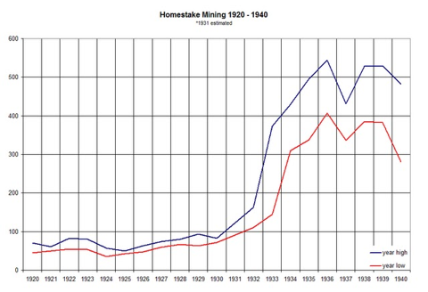
I was not really able to find out much about the price of HM over the 125 years it was listed as a research library containing that sort of information was unavailable.  However, I did notice that HM was one of the top performers during the Bear Market associated with the “Great Depression” of the 1930s.  In October 1929 the stock sold for ~$80 and by the end of 1935 it reached $495 (http://seekingalpha.com).  That is a return of ~520%, and does not include any of the cash dividends paid to stockholders. Goldbugs are still talking about that surge in price as traders attempt to lure consumers into investing in gold stocks or bullion.

I have some difficulty deciphering all of these stock prices but it appears that on November 24, 1937, Mrs. Margaret R. Barker purchased 100 shares of HM at a price of about $350-$500.  It is difficult to determine without accurate historical date but the chart below seems to indicate that price range.
Chart supplied from http://seekingalpha.com.  The high price for HM in 1937 was about $500 per share (upper chart line) while the low was about $350.

Mrs. Barkers certificate was numbered 12019.  Three years later on December 30, 1941 Mrs. Barker sold the stock for $3,400 or $340 per share---see receipt below from Thomson and McKinnon.  The most interesting aspect of this sale receipt is the Stock Transfer Tax stamps affixed—a $4 stamp, three $.25 stamps, and three $.01.  Evidently it cost Mrs. Barker $3.78 to sell her 100 shares of HM.  In reading about the date of the sale I wonder if Mrs. Baker was concerned about stock prices during the ongoing war.  After all it was only three weeks after the onset of World War II.
Receipt showing sale of 100 shares of HM.  Note Stock Transfer Tax stamps.

And finally, I have a receipt showing that 100 shares of HM with the certificate number of 12019 were transferred to Mrs. Florence B. Nessa of Sioux Falls, SD, on January 2, 1942.
Sale of 100 shares receipt dated 1942.
So, old stock certificates (this one is nearly 80 years old) can result in an interesting story including noting the signature of Edward H. Clark, the President of Homestake Mining from 1914-1944, and learning about Stock Transfer Tax stamps..     

Monday, September 12, 2016

SILVER FROM THE BLACK HILLS, SOUTH DAKOTA


I love the back roads of the Black Hills, puttering along looking at the scenery (back side of Mt. Roosevelt north of Lead), checking out the rocks, and just enjoying life.  Hopefully when my knee is "fixed" this fall (second time) I will be able to take the walk to the summit (5690 feet).
The Black Hills of South Dakota remain one of my favorite places to tromp around, camp, collect minerals, visit brew pubs and rock shops, and generally enjoy life.  As noted in numerous other Blogs postings, I started enjoying the Hills during a summer visit in 1964 and this affection affair continued during my two years of graduate school at the University of South Dakota.  Although Vermillion is about as far from the Hills (~400 miles) as you can get and still be in South Dakota, I was able to make numerous trips west with my friends from that part of the state.  You know, in your early 20s distance in a car really didn’t mean much.  Road trip?  Let’s go!  Classes out Friday afternoon and we will be back in town in time for classes Monday morning. I distinctly remember one weekend when we decided to head to the Hills for a bit of cave exploration.  I don’t have the slightest idea of the cave we explored; however, we were staying in Edgemont so I assume it was north of there in the Paleozoic limestone.  Two things stick out in my mind: 1) my buddies were not the really good friends with the land owner as they thought and since I was driving on the way out it was my rear that received the brunt of the chewing.  I took it with a “yes sir” attitude since he also was waiving a gun in the air; 2) I am claustrophobic and certainly will not enter into the dark areas of a cave; therefore, I stayed in front where I could always see the opening.  Well, a couple of the boys got a little confused back in the dark and just as we decided to go for help they appeared with a befuddled mind but physically OK.  That was when I started the drive out of the pasture. 

In summer 1966 I spent weekends chasing rocks in the badlands east of the Hills with periodic forays into the high country.  Since those halcyon days of youth, I have continued my visits by attending professional meetings, camping and fishing in the woods, and in my later years collecting minerals---in contrast to my professional life of collecting vertebrate fossils.  Many of these minerals are documented in Blog postings and several more are in line for the future.

The southern and central Hills certainly have many attractions but most tourists are there to visit Mt. Rushmore (often on their way to Yellowstone) with perhaps side trips to Wind Cave National Park, Jewel Cave National Monument or the Hot Springs Mammoth Site.  Several hundred visitors show up for the late September buffalo roundup in Custer State Park.  In the northern Hills the major attraction seems to be Deadwood where numerous gambling casinos are mining gold from their customers.  In “olden days” gold was produced from streams, small mines or open pits but mostly from the giant Homestake Mine in the town of Lead (pronounced leed, unlike the metallic element produced from galena ore)---located next door to Deadwood.
Ore cars removing ore from an adit at the Homestake Mine.  Not abandoned adits in the wall of the open pit shown below.  Photo taken in 1906 and courtesy of the Library of Congress.
I was able to visit the Homestake once as a student; however, our handlers kept a close rein on us.  As an adult, I always enjoy looking at the open pit from an observation platform in downtown Lead.  Next door to the platform is a small museum with great descriptions and photographs.  If you are in the northern Hills, the Homestake is well worth a visit.


The "open pit" as viewed from the museum in downtown Lead.  The Precambrian Homestake (H) Formation is the gold-bearing unit at the Mine.  The light colored rocks at intrusive rhyolite dikes (r) cutting through the Homestake but "flattening out" as the reach the Cambrian Deadwood Formation (D) above. The dikes are associated with tectonic and igneous activity in the Hills about 55 Ma.  The unconformity, the "missing time," between the Precambrian Homestake Formation and the overlying Cambrian Deadwood Formation represents about 1.5 billion years!    
The Homestake gold mine had a long history after the original claim was filed in 1876.  I use the past tense as gold mining ceased in 2002 when productions costs exceeded any “profits.”  However, the mine did not “die” since in 2007 the National Science Foundation begin funding the Deep Underground Science and Engineering Laboratory.  However, in 2010 the Foundation dropped its sponsorship but in 2011 the Department of Energy, along with the South Dakota Science and Technology Authority, agreed to fund research and give management authority to the famed Lawrence Berkeley National Laboratory although the facility is known as the Sanford laboratory after a major contributor, T. Denny Sanford.  If you want to know more about the Deep Underground Neutrino Experiment at the lab, hug your favorite physicist and buy her a cup of coffee and ask for an explanation.  Be prepared for some wild talk!
The Stanford Visitor Center housing the museum.

One of the amazing exhibits inside the museum (and difficult to photograph) is a metal representation of the adits, shafts and tunnels of the underground Homestake Mine,
Many readers will know that the original discovery of gold, at least by explorers of European descent, was made by the Custer Expedition of 1874.  There is a very long story about this expedition and the discovery but that is for another time.  Needless to say that the Native American population was not really pleased with the gold seekers migration into the Hills; however, here they came.  First to the Custer area, where placer gold was discovered by the Expedition, and later scattering to various other parts of the Hills.  In late 1875 prospectors leaving the Custer vicinity for “greener pastures” discovered placer gold with decent color in the creeks near the present town of Deadwood and a new rush was on to the northern Hills. A couple of itinerant prospectors, brothers in fact, by the name of Fred and Moses Manuel decided to hunt for the “mother lode” upstream from the placer work.  Both had worked in California as hard rock miners and evidently remembered that the placer gold had to come from upstream in some sort of a vein in the “hard rock.”  In 1876 they filed a claim on their “mother lode” and named it the Homestake Lode.  The boys sold the claim and by 1877 a member of the Hearst family had taken firm control and by 1879 the Homestake Mining Company was listed on the New York Stock Exchange and ultimately became the longest listed stock (HM) in the history of the Exchange.  The company then begin to buy, or take by force, surrounding claims and an empire was built.  Those of us of a certain age remember the year 1974 and the debacle associated with the kidnapping of a descendent of the Homestake riches---Patty Hearst.

The Homestake Mine became the deepest mine in the US, ~8000 feet, the largest single producer of gold (nearly 40 million ounces by 2001) although several mines combined in the Carlin District of Nevada have a larger total production.  In 2000 the Homestake Mining Company announced plans to shut down the Homestake Mine since the ore was very low grade (about a quarter ounce per ton), production costs were high, and the price of gold was low.  In 2001 Homestake Mining was acquired by the Barrack Gold Corporation (trading as ABX and closing at $17.01 on 31 August 16) and HM disappeared from the Big Board.  HM had experienced a monumental fall from ~$5000 per share in 1987 (http://seekingalpha.com/article/234105) to barely over $3 per share in late 2000.

The best accessible description of the geology at the Homestake Mine is found in the Guidebook to Geology of the Black Hills, South Dakota (Lufkin and others, 2009).  The gold-producing rocks at the Homestake are Precambrian in age and metamorphic iron-bearing rocks (BIF, Banded Iron Formation) known as the Homestake Formation. Lufkin and others (2009) noted the possibility of two origins for the gold.  Rye and Rye (1974) presented data that indicated the Homestake Formation was the result of hot springs spewing forth from an ocean floor, perhaps something like the “black smokers” known today. The gold would have been dissolved in a hot aqueous solution and would have been deposited, along with numerous other minerals including the iron and silica, when there was a large-scale change in the solution, perhaps a sharp drop in solution temperature.  DeWitt and others (1995) agreed and stated:  “Most large gold deposits in iron-formation (GDIF) are strata-bound, bed-controlled concentrations of sulfide minerals and gold that were probably formed by syngenetic [occurring at the same time], hot-spring processes during deposition of iron-formation.

[The] Iron-formation and layered, bed-controlled sulfide mineral deposits were deposited on the seafloor under extremely reducing conditions, in an environment that contained abundant organic carbon and iron and variable amounts of sulfur. Gold abundances are highly correlated with either those of pyrrhotite and troilite or with that of arsenopyrite [the case at Homestake], depending on the physical-chemical conditions of hot-spring activity.”

Bachman and Caddey (1990) believed the gold deposition was epigenetic [occurring at a later time], and perhaps due to a later period of metamorphism after deposition of the original BIF.  Gold-bearing solutions would have migrated along shear and fault zones and finally locate in the Homestake Formation.

Whatever the case, the Homestake produced a really large amount of gold, but what about its buddy, silver?  There are numerous publications and stories about the gold from Homestake; however, I have been unable to locate much information about silver from the Mine, or even from the northern Hills.  I know that silver was mined at Homestake for Bachman and Caddey (1990) noted that in the 1980s the Mine produced as much as 300,000 ounces of gold in some years with a ration of gold to silver as 5:1.  That would mean that perhaps ~60,000 ounces of silver was produced each year.  MinDat.org noted that “native Au [gold from Homestake] contains an average of 17% Ag [silver].  DeWitt and others (1995) also gave me the answer in describing the mineral deposits at the Homestake: “Deposits are concentrations of electrum and the sulfide minerals troilite, pyrrhotite, pyrite, and arsenopyrite, and include electrum in carbonate-facies iron-formations, and are mined for gold and silver.”  Electrum is a natural mixture of gold and silver but is normally called by the name of the dominant element---at Homestake that would be gold. So, it appears that the silver at Homestake was produced as a by-product of the gold recovery process. 
The gold in the Homestake Formation is often associated with quartz (Q) and arsenopyrite (A; an iron arsenic sulfide)).  This specimen was acquired many decades ago during a field trip.
Fibrous radial cummingtonite, an amphibole with prismatic to fibrous crystals, translucent,vitreous to waxy, green to brown-green color.  It is a magnesium-dominated silicate  {Mg2}{Mg2}(Si8O22)(OH).  This mineral formed during a metamorphic event when the Homestake and other formations were folded and bent in the Precambrian. Cummingtonite is in solid solution with grunerite, a mineral where iron replaces the magnesium.  Therefore, this specimen is probably an intermediate between pure iron and pure magnesium. It was randomly "picked up" decades ago. Width FOV ~1.0 cm.
What got me started on this little project about the Homestake is that one of the micromounts purchased at the Willard Wulff estate sale [see previous Blog posting 7-28-16) is a small specimen of native silver crystals labeled “Homestake Mine, So. Dakota.”  Originally the specimen was in the collection of “C. Withers.”  That would be Carroll “Shorty” Withers, a prominent Colorado micromounter who was inducted into the Micromounters Hall of Fame in1981, the same year that he died.
So, a specimen of native silver does not seem like a big deal.  For example, thousands have been collected from numerous localities in Colorado such as Creede and Leadville.  However, I have not been able to locate photos or references to silver crystals from the Homestake.  I suppose most miners were interested in bringing native gold up in their lunch boxes, or perhaps virtually all silver was tied up with gold in electrum.  At any rate, the specimen interested both Withers and Wulff. 
---and now me.
Silver crystals.  Length ~1.6 cm.

REFERENCES CITED

Bachman, R.L., and S.W. Caddey, 1990, The Homestake iron-formation-hosted gold deposit, Lead; Road log for surface tour, in Paterson, C.J., and Lisenbee, A.L., eds., Metallogeny of gold in the Black Hills, South Dakota: Society of Economic Geologists Guidebook Series, v. 7.

DeWitt, E., W.D. Heran, and M. D, Kleinkopf, 1995, Stratabound Au in iron-formations (Model 36b; Berger, 1986) in Preliminary Compilation of Descriptive Geoenvironmental Mineral Deposit Models, E.A. du Bray, ed.: United States Geological Survey Open-File Report 95-0831. 

Lufkin, J.L., J.A. Redden, A.L. Lisenbee and T. Loomis, 2009, Guidebook to the Geology of the Black Hills, South Dakota: Golden Publishers, Golden, CO. 

Rye, D.M., and R.O. Rye, 1974, Homestake Gold Mine, South Dakota; 1. Stable isotope studies: Economic Geology, v. 69.

HOMESTAKE POWER: REALLY BIG STUFF

The following taken from: www.nevada-outback-gems.com/Gold_rush_history/South_Dakota/S_Dakota10.htm
 
 The celebrated Corliss engine, of three hundred horse-power, shipped from Providence, R. I., is the largest ever brought into the territories. It weighs eighty-nine thousand pounds, and has two flywheels fifty-six feet in circumference. The cylinder is twenty-six by twenty-eight inches, and the arm attached to the fly-wheel, weighs eight thousand six hundred pounds. The engine is set in the centre of one end of the building, and rests on eleven stones laid in hydraulic cement. These stones weigh eighteen thousand pounds each. Two line shafts on each side of the building have Walden & Mason's patent friction pulleys to drive the stamps. The great benefit of the patent friction pulleys is, that each ten stamps of the mill can be stopped by means of friction, the shoes being thrown in or out of gear by a lever without interfering with the motion of the mill. Three of Blake's largest size rock breakers are set in the top of the mill, so arranged that the rock when partially crushed passes to twenty-four of Hendy's patent self-feeders, placed in the rear of the stamps. The mortars are lined with copper and have improved screens. The stamps weigh eight hundred pounds each. The Hendy concentrator is a new feature in this part of the country. There are twenty-four of these placed at the end of each plate, so that, as a battery or plate, it is saved by the concentrator. The tailings coming from the plates are run into the concentrator, which acts upon the same principle as we would pan out dirt by hand. This is only needed when the pyrite or sulfides of iron contain gold, as quicksilver will not act upon pyrites of iron. The machinery weighs over one million pounds, and the belting used weighs over three tons. The mill cost two hundred thousand dollars.
The hoisting machinery consists of two twelve by twenty-four engines of seventy-five horse-power, which are capable of raising two tons four hundred feet per minute; two reels for hoisting, supplied with a steel wire cable which will sink the shaft to a depth of one thousand feet. This cable is a most powerful and costly one, being two and three-fourths of an inch in diameter, weighing one pound and a quarter to the foot. Added to this is a six-inch drawing and lifting pump, with five-feet stroke, having a capacity of five thousand gallons per hour.