Tuesday, July 22, 2025

"GOING UP THE COUNTRY": COLLECTING COQUIMBITE: SAN RAFAEL SWELL


I have noted in other articles about my academic move from Vermillion, SD, to Salt Lake City, UT. It was the case of a small-town Kansas kid moving west to the mountains of his youthful dreams. How many times had he ogled at the advertisements in the back pages of “outdoor’ magazines promising a job as a “forest ranger” or maybe even a ”government trapper?” How many times during his high school and undergrad days had he applied for a summer position in one of the national forests---any job would do?  But, as usual, he spent his hot Kansas summers working at his father’s gasoline station and/or driving a tractor for his uncle. But hey, it was money in the bank.

Now a journey to the mountains was “for real” and I (along with a new youthful bride) were off to follow the mountain men explorers, although as a geologist rather than a beaver trapper. There were so many new places with rocks and fossils and peaks and deserts that were absent in the Plains. What a fantastic time to be a geologist but also realizing that there was so much to learn. Those feelings are still with me today!

Early on in my University of Utah days one of my fellow grad students suggested a long Saturday field trip to the San Rafael Swell near Price, Utah. So off we go with rock hammers, lunch, cameras, and for me—a great deal of excitement. At that point in my life, I didn’t have the slightest idea of what the Swell was, nor what we would see on a field trip. All was new; most rockhounds can attest to this thrill building up as the week winds down for a Saturday field trip!

Cliffs of Cretaceous rocks forming a western boundary to the Swell.
 

After a main highway sojourn, we finally turned onto a gravel/dirt road and I became absolutely amazed at the sights. To the west were the towering blue to blue-gray cliffs of the Cretaceous Mancos Shale. These marine rocks were part of the Western Interior Seaway that once extended from the Arctic Ocean south to the Gulf of Mexico and from Utah through Kansas (in today’s geographic terminology). As we traversed down section into the Swell, I could recognize the older Cretaceous Cedar Mountain and Dakota/Naturita Formations, the Jurassic dinosaur-bearing Morrison Formation and then into the majestic red rocks of Jurassic, Triassic, and Permian age complete with deep canyons, high cliffs, and lookouts where you could gaze for tens of miles without seeing human habitation. While eating lunch on a large boulder in the lazy warm sun I think my spouse had an epiphany on why I wanted to become a professional geologist and work “in the West.” And so, she accompanied me almost every summer for 20 years as I hauled my undergrad students around the “West” to help me with research projects, or to direct grad students on their own projects. Just as I fell in love with the Black Hills during my South Dakota days, I fell head over heels for the Colorado Plateau and especially the San Rafael Swell.


Rocks to impress a flatlander and love forever.
  

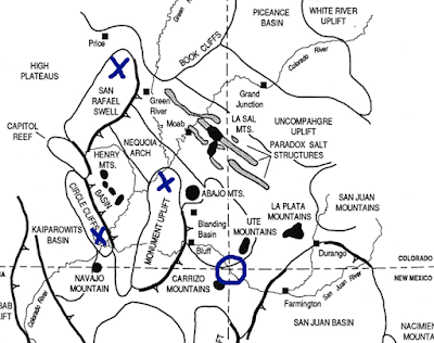
Geologically, the southwest quadrant of Utah, part of the Colorado Plateau Physiographic Province, is dominated by several small anticlinal uplifts and larger laccolitic peaks.  By small, I mean the anticlines do not approach the size of time-related (Laramide Orogeny) mountain ranges such as the Uinta Range, but still extend tens of miles in length.  The “big” anticlinal mountains expose Precambrian rocks in the center that usually form the high peaks.  The “smaller” upwarps usually have rocks no older than Pennsylvanian in the center.  However, there are some spectacular folds and “bent” rocks within these upwarps. The best-known upwarp features in Utah are the Monument Upwarp, the San Rafael Swell (a large anticlinal uplift with a steeply dipping and folded eastern margin termed the San Rafael Reef) and the Circle Cliffs Uplift (a north-south doubly-plunging anticline with a steeply dipping (almost vertical) eastern margin, the Waterpocket Fold).  These large upwarps “were formed by tangential compressional forces that were episodically repeated throughout the Phanerozoic [post Precambrian] and most magnificently accentuated by Laramide and younger tectonism” (Stevenson, 2000).


A map of the mountains

AI-generated content may be incorrect.

Laramide anticlinal uplifts centered around Four Corners Region (X).  Original source unknown but commonly attributed to Don Barrs.


A satellite view of a desert

AI-generated content may be incorrect.

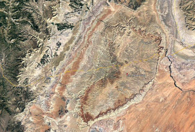
Google Earth© image of “bean-shaped” San Rafael Swell in Emery County, Utah. The San Rafael Reef (steeply dipping beds) is the “toothed” area in the southeast. 

To a small town flatlander like me, the scenery I saw that 1967 day in the Swell was almost overwhelming. I was swimming in sensory overload and could not quite contemplate what was going on. As a want-ta-be geologist I had a thousand questions and was thinking about a future dissertation project—and about blew my mind.


The small knob was the site of the Rough Road Quarry in the Cedar Mountain Formation.  See Eaton and Nelson in References Cited. 

Well, I never settled on a dissertation project in the Swell but later spent the better part of three years hunting for Cretaceous mammals in the Cedar Mountain Formation and supervising four MS students working on theses. My project turned out reasonably well as the Rough Road Quarry produced numerous small mammal, reptile, and “fish” specimens. This work was started when mammals were almost unknown in the Early Cretaceous rocks of the U.S. and before the famous Utahraptor  discovery in the Cedar Mountain near Moab set off a massive paleontological hunt in the unit. About the same time as my work in the late 1980s-early1990s paleontologists from Weber State University and the University of Oklahoma hit the jackpot with several new quarries, and major finds of mammals, in the unit. As for me, I ventured over to the world of university administration.

During those early years of my stay at the University of Utah all roads into the Swell were essentially graded native rock, sediment and “dirt.” I was stranded and “stuck” more than once when the bentonitic sediment became wet. Visitors were few and the camping and exploring were great and so for the following 20 years the Swell was our “go to” place to escape. I was especially drawn to the Cleveland-Lloyd Dinosaur Quarry where Jim Madsen, my good friend and research companion, spent most of his summer months.

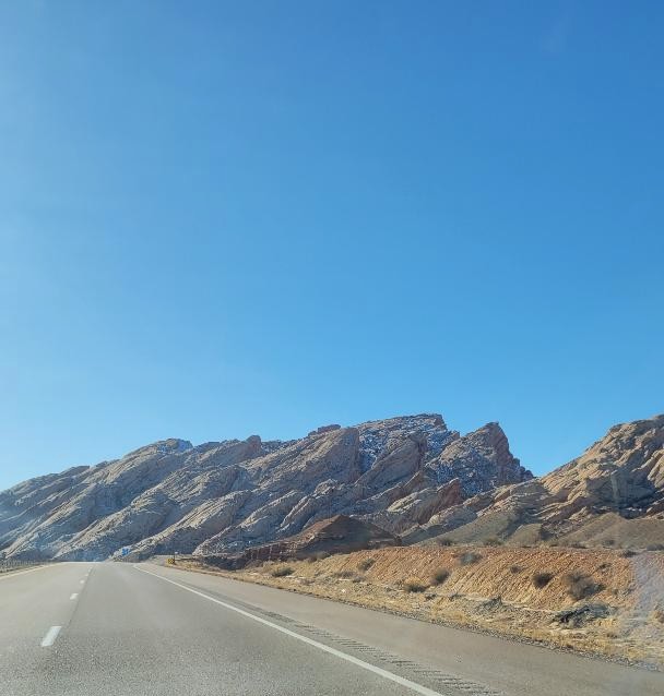
The University of Utah scientists began studies on San Rafael Swell dinosaurs in the 1920s followed by paleontologists from Princeton University. In 1960 the University of Utah commenced a 5-year project with several cooperating schools under the administrative leadership of Dr. William Lee Stokes and field leadership of Madsen. In those days the quarry was protected from the elements by a corrugated roof structure with few other accommodations. Today the Quarry and a few surrounding acres have been designated as Jurassic National Monument and a new museum-like building has been constructed. Over the years, bones have been taken from the quarry representing at least 70 different animals and 11 species. Cast and original skeletons assembled from these bones are on display in over 60 museums worldwide.

Cleveland-Lloyd Dinosaur Quarry in Jurassic National Monument. Public Domain photo by Richard M. Warnick.

The Swell opened for travelers to catch sight of the fantastic scenery when I-70 in Utah was partially completed and opened as two lanes in late 1970. However, total construction and dedication was not completed until 1990. The Swell is still a rather uncrowded hunk of land perhaps best known by road warriors as the longest stretch of Interstate highway, 110 miles between Salina and Green River, without any urban development or services for visitors—fill up the gasoline tank before travel. 

I suppose most people traversing through the Swell, especially those in a hurry and those without an appreciation for desert scenery, might remember the gate to the eastern section. Here, I-70 cuts through the upturned rock known as the San Rafael Reef. It is an amazing bit of travel through Jurassic and Triassic rocks.     


A winding road through a canyon

AI-generated content may be incorrect. 


A road going through a canyon

AI-generated content may be incorrect.

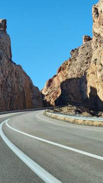
 Driving I-70 through the upturned rocks of the San Rafael Reef approaching from the east (lower three photos), and approaching from the west (upper photo. 

Rockhounding in the Swell is sort of a mixed bag. MinDat lists a total of 83 valid minerals (Type Localities for three uranium minerals) found in the San Rafael Swell Mining District, a fishhook shaped area covering the eastern and southern exposures. Research by thediggings dot com noted the following number of mines and prospects in the District: includes 5493 nearby claims—39 active and 5454 closed—and 183 nearby mines—49 occurrences, 28 prospects, and 106 producers.  Virtually all  mines and prospects were after uranium and/or vanadium from the Chinle Formation with perhaps a little copper thrown in, maybe a tad of zinc and lead. After World War II  the need for uranium to fund the Atomic Energy Commission (AEC) projects created a large boom in the late 1940’s and 1950’s and brought thousands of prospectors, miners and merchants to Utah, including a ‘rags-to-riches” Texan by the name of Charlie Steen.  His discovery, in 1952, of the Mi Vida (My Life) mine near Moab triggered a “uranium rush” to the Colorado Plateau that rivaled the fabled gold rushes of the 1800’s.  School teachers, insurance brokers, used car salesmen, and shoe clerks around the nation converged on the Colorado Plateau to seek their fortune.  Even a group of high school students staked forty claims and later sold them for $15,000.  By the mid-1950s, almost six hundred producers on the Colorado Plateau were shipping uranium ore.  Employment in the industry topped 8,000 workers in the mines and mills.  Another bonanza in penny uranium stock established Salt Lake City as The Wall Street of Uranium.  The AEC had turned the tap and caused a flood. By 1960 Utah was producing in excess of 6.5 million pounds of uranium; however, in 1964 the AEC decided to stop purchasing uranium and the bust cycle was on (Ringholz, 2009), although there have been a few minor boom cycles in the last 50 years.

 I sort of refuse to touch most radioactive minerals and have never really been interested in collecting such, especially specimens containing any sort of uranium. In fact, my collecting habits in the Swell have been tied to fossils and various types of micro crystalline quartz with a few pieces of “petrified” wood thrown in. However, I have enjoyed taking a look at several of the abandoned uranium/vanadium mines but have never ventured near the mine entrances. I am quite claustrophobic and don’t want to take any chance of a poisonous gas leaking out. In other words, I could/would not work in the mining industry where underground journeys were required. I am certain this habit kept me from finding a plethora of nifty mineral specimens!

The "old" bridge crossing the San Rafael River in the middle of the Swell. It was infamous for moaning and groaning and sagging whenever a car slowly crept from one bank to the other. A new ugly, concrete bridge, seen to the left, was offered as a replacement. 

Calf Mesa is a well know area in the northern part of the large San Rafael Mining District, not far from the "old bridge". The Rim of the Mesa is mostly composed of the Entrada Formation although small “slivers” of the overlying Curtis Formation may be present. Underlying the Entrada is the Chinle Formation that contains a sandstone/conglomeratic, channel-fill, unit variously referred to as the Shinarump Member or the Moss Back Member that are/were the major producers of uranium and vanadium in the San Rafael Swell. A cluster of mines along the side of the Mesa has produced 28 valid minerals according to MinDat. The best known of the Calf Mesa Mines is the Dexter #7. According MinDat the Mine, from 1950 through 1957, produced more than 500 tons of ore which averaged about 0.27 percent Uranium 308 and 0.05 percent Vanadium 205. Today the Mine is long abandoned; however, the large scattering of mine equipment, the ease of locating and accessing the mine (if you like to walk), and the chance of collecting rare to uncommon iron sulfate minerals such as butlerite, copiapite, coquimbite, krausite, melanterite, romerite, voltaite, and goldichite (the Type Locality) attracts a variety of specimen collectors. However, it now appears that rockhounds have company at Calf Mesa as ” Anfield Energy Inc., a uranium and vanadium mining company based in Vancouver, British Columbia, Canada, [Anfield purchased in late 2024 by Isoenergy Ltd.] has purchased a 100 percent interest in 26 unpatented mining claims of the Calf Mesa uranium project, located in Emery County” (Salt Lake Business Journal, 14 January 2023).

The rim of Calf Mesa. Photo courtesy of Dennis Udink, Price, UT 

Probably the most collectable mineral from the Dexter #7 is the uncommon, hydrated, iron sulfate coquimbite: AlFe3(SO4)6(H2O)12·6H2O. Crystals are colorless to lavender to purple to pink to greenish to yellowish---often in the same specimen. They usually are short prismatic with small unequal pyramidal faces. Crystals are transparent, sub-vitreous to resinous and quite soft at 2.0-2.5 (Mohs), brittle with a sub0conchoidal fracture and a whit streak. They would, at first, be tough to identify (for an old plugger like me) unless one knew the collecting locality—arid region as a secondary mineral in oxidized sulfide deposits. It also may form in volcanic fumaroles and/or in underground mine fires. Whatever the case, once one sees the crystals the identity seems to stick in your mind.


Clear to light purple or lavender sub-millimeter crystals of coquimbite (color varies across specimen). Also present are the hydrated iron sulfates halotrichite (H white fibrous encrustations), voltaite (V dark green to mostly "black"), romerite (R brownish orange), and a yellow unknown mineral, probably copiapite (?C) but possibly some goldichite? These latter minerals are even smaller than the coquimbite and tough to identify.


Searching for fossils in the mudstone outcrops of the Cedar Mountain Formation. Take your canteen and a snack and a Brunton.

 There is no shortage of water in the desert but exactly the right amount , a perfect ratio of water to rock, water to sand, insuring that wide free open, generous spacing among plants and animals, homes and towns and cities, which makes the arid West so different from any other part of the nation.  Edward Abbey 

REFERENCES CITED

 Ringholz, R. C., 2009, Utah’s Uranium Boom in Beehive 16, Utah History to Go:  http://historytogo.utah.gov/   

*Going up the country is the title of a song by Canned Heat

OF INTEREST

Pomes, Michael L., "Stratigraphy, Paleontology and Paleobiogeography of Lower Vertebrates from the Cedar Mountain Formation (Lower Cretaceous), Emery County, Utah" (1988). Master's Thesis.

Conley, Steven J., "Stratigraphy and Depositional Environment of the Buckhorn Conglomerate Member of the Cedar Mountain Formation (Lower Cretaceous), Central Utah" (1986). Master's Thesis.

Crooks, Deborah M., "Petrology and Stratigraphy of the Morrison (Upper Jurassic) and Cedar Mountain (Lower Cretaceous) Formations, Emery County, Utah" (1986). Master's Thesis..

Hunter, David A., Stratigraphy, Sedimentation, and Paleoenvironment of the Cedar Mountain Formation and the Dakota Sandstone (Cretaceous) in West-Central Emery County, Utah” (1990). Master's Thesis.

Nelson, M. E., and Crooks, D. M., 1987, Stratigraphy and paleontology of the Cedar Mountain Formation (Lower Cretaceous), eastern Emery County, Utah, in Averett, W. R., editor, Paleontology of the Dinosaur Triangle--guidebook for 1987 field trip: Grand Junction, Colorado, Museum of Western Colorado, p. 55-63

Eaton, J.G. & Nelson, M.E.  1991.  Multituberculate mammals from the lower Cretaceous Cedar Mountain  Formation, San Rafael Swell, Utah.  Contributions to Geology, University of Wyoming, 20:1-12.


Wednesday, July 2, 2025

OLD IS GOOD! HELP FOR FOSSIl IDENTIICATION


My geology/mineral/rockhound Blog (my only bow to social media) often receives a variety of questions from readers. I might write a post on a particular mineral but receive  questions like: Can you help me? I found this rock in my backyard, and it looks like a fossil. Do you know what it is? I like to collect fossils in the rocks around my farm. How may I learn to identify them? The questions usually require several more exchanges of information before I can give a best judgement call, but readers do get an answer.

Now, depending upon their interests and perhaps future collecting plans, I suggest publications that could be acquired and that would help with their identifications. Some of my suggestions are free on the Internet, most are available from used book dealers, and most are found in university libraries. As a last resort I will also scan some illustrations and send them via email if they request further help. Depending upon their collecting habits I might supply some information on collecting rules and regulations. No two questions, or answers, are the same but mostly all are enjoyable.

There are a ton of paleontological articles on the Internet. However, many are highly technical, and many are difficult to locate. Often a technical article only describes a particular taxon and that is not very useful to a kid trying to identify the clam she found in the roadcut.

I am an “old-fossil” type of guy so that qualifies me to talk about the “old days”. Well, in the old days, say 1900s in the U.S., research universities, the U.S. Geological Survey, and many state geological surveys, supported some “really smart” invertebrate paleontologists who published textbooks and research publications with hundreds/thousands of photographs or line drawings of fossils. Sometime in the late 1900s it became monetarily prohibitive to publish an article with 200 photographs of fossils. But readers should sometime visit the archives, or stacks, of university libraries and peruse the older USGS Professional Papers, the vast resources of the state geological surveys, and even publications of the state academies of science. In fact, one could enjoy large swaths of winter days bundled away in the library, forgetting the problems of the world,  and enjoying the company of Edward Drinker Cope.

As my article title indicated, Old is Good, and so my recommendations for identifying fossils, especially from states in my area of the country, are publications from the 1900s. All are packed with photographs or line drawings. Now there is a caveat to using older publications for fossil identifications—the fossil in question may have been switched from one taxon to another or changed its identification. But, one can come very close to the identification and then run that term through an Internet search.

I will focus on invertebrate fossils since these are of the most interest to rockhounds. And of course, my recommendations are simply my choices.


Index Fossils of North America

The best single book to acquire and have in your paleontological library is Index Fossils of North America, Hervey Shimer and Robert Shrock, 1944, John Wiley and Sons, Inc. (there may be later reprint editions). This tome is a revision of Grabau and Shimer’s 1915 classic North American Index Fossils. Known affectionally as the “Blue Book”, this amazing work describes and figures over 7,500 species with over 9,400 illustrations on 303 full page plates. It contains selected bibliographies for all the larger divisions and considers geographic as well as geologic distribution on 837 pages!

A page from Index Fossils (poorly copied).

Used copies are available from Internet used book dealers for somewhere around $75-$100 and is well worth the money if you are interested in collecting and identifying invertebrate fossils. If uninterested in shelling out a Benjamin, I have located a site to download a FREE copy. Use your browser and search for Internet Archive Index Fossils of North America. Sign up for free and download—an amazing gift.


Invertebrate Paleontology; More and others.

An older university textbook loved by all (well mostly loved) is entitled Invertebrate Fossils, 1952. by R.C. Moore, Lalicker, and Fisher and published by McGraw Hill. Moore, from the University of Kansas, was one of the best-known invertebrate paleontologists in the middle decades of the 1900s (check out his bio on Wikipedia). This was the standard “go-to” paleo textbook for college students for a quarter of a century as it is profusely illustrated with line drawings.


A page of illustrated fossils from Invertebrate Paleontology

Even today, fossil hounds look for, and are able to purchase, used copies for $30+. But again, FREE copies are available for download on Internet Archive (note instructions above).  

Kansas Geological Survey Bulletin 14.

Living in Kansas for several decades, I was always interested in collecting fossils from marine rocks of Pennsylvanian, Mississippian (Carboniferous) and Permian ages. These fossiliferous rocks are abundantly exposed in eastern Nebraska and Kansas over into Missouri, Arkansas, and Oklahoma. I fact, Carboniferous and Permian rocks crop out in many states but seem most fossiliferous in the middle of the nation. With that information I wish to recommend a paper by R.C. Moore    published in Bulletin 169 of the Kansas Geological Survey: Palaeoecological aspects of Kansas Pennsylvanian and Permian cyclothems, pp. 287-380. The paper has fantastic line drawings that will help you identify virtually all Pennsylvanian and Permian marine fossils you will ever collect in the central U.S. Many of these illustrated fossils may also be located in other states. The best part is that the Survey will allow you to download papers from Bulletin 169 for FREE. You can’t beat that. Head to:  KGS--Bulletin 169--Symposium on cyclic sedimentation


Page of illustrated Pennsylvanian and Permian gastropods from Bulletin 169.

And finally, fossils of Cretaceous age are found in rocks cropping out in all central U.S states. Many/most of the marine rocks are associated with deposition in the Western Interior Seaway; therefore, the fossils are very similar in all outcrops. For example, although species of the Inoceramid bivalves may vary from Texas to Utah they are easily identified as the clam and can be keyed out.

Professional Papers of the USGS are great resources for determining and identifying fossils in specific stratigraphic units. However, it will take some internet sleuthing. My go-to book for identifying virtually every Cretaceous fossil that I have observed is Vol. 14, Nos. 3 & 4 of The Mountain Geologist, a peer reviewed publication of the Rocky Mountain Association of Geologists. Edited by Earle Kauffman, this 1977 classic served as a field trip guidebook for the North American Paleontology Convention II. Not only are Cretaceous fossils well illustrated with photographs, but field trip stops at various locations from Salt Lake City to central Kansas are described.


The Mountain Geologist, Vol. 14, Nos. 3-4.


A page of fossil illustrations from the Mountain Geologist.

Unfortunately, this publication is almost impossible to purchase. It periodically shows up on internet used book sites, but those buying chances seem rare. But there seems to be a solution from RMAG.org, move to publications, move to The Mountain Geologist, move to AAPG Datapages, verify you are human, fill in form: Full Text Bulletin 14, Year 1977 to 1977, Select 1977. You may then order any of the individual road logs or if interested in just the fossils, place an order for the Illustrated Guide…..at $24. Universities in the Mountain West region also may subscribe to RMAG publications that are available for examination in the library.

And finally for the hard-core fossil hounds, there is the Treatise on Invertebrate Paleontology, described by the University of Kansas, the publisher, as a definitive reference work that encompasses approximately 55 volumes published from 1953 to the present. It is authored by over 300 paleontologists and provides extensive information on every phylum, class, order, family, and genus of both fossil and extant invertebrate animals. The treatise includes detailed descriptions of prehistoric invertebrates, covering aspects such as taxonomy, morphology, paleoecology, and stratigraphic ranges.


An early Treatise volume.

The Treatise is available for open access, allowing users to download entire volumes or individual chapters in PDF format. This accessibility is facilitated through the University of Kansas website, where users can search for specific topics or browse through the available volumes. The content is provided under a Creative Commons Attribution 4.0 (CC BY) license, promoting its use in research and education.

In summary, I have tried to provide references for interested fossil hounds to help with identifications of collected specimens. The references noted provide line drawings or photographs that will help collectors of all ages or experiences. Good luck and if you run into problems just shoot me an email. 


Wednesday, May 7, 2025

IRON ORE. BOUNDARY WATERS, AND BIG FITZ

 How many roads must a person walk down

before you call them a rockhound?  Apologies to Bob Dylan

At one time in my geological past, I organized and led student field trips to the Boundary Waters Canoe Area in Northern Minnesota. Driving north from Hays, Kansas, our group observed and studied various rock units that were unavailable to see in the sedimentary section of western Kansas. For example, we took a good look (and camped) at exposures of the Proterozoic Precambrian Sioux Quartzite (~1.6-1.7 Ga) cropping out around Sioux Falls, South Dakota, and adjacent western Minnesota. These outcrops were a good eye opener for the kiddies since their previous observation of the quartzite was in a pasture in eastern Kansas where I had previously stopped during a paleontology field trip. At this cow pasture locality, the Sioux was observed as small cobbles and boulders, the result of riding down glacial ice during the Pleistocene. The glacier(s) plucked the distinctive pink quartzite from the South Dakota/ Minnesota outcrops and dropped them off in a terminal moraine in eastern Kansas. These two areas presented a great message to help students understand the power of  glaciers.

Sioux Quartzite exposed at the “falls” in the city of Sioux Falls.  Photo courtesy of Steve Dutch, University of Wisconsin.


Sources of identifiable glacial erratics found in northeastern Kansas. The dashed line represents the extent of Pleistocene glacier(s) in Kansas.  Map courtesy of Kansas Geological Survey.
 

Boulders and cobbles of Sioux Quartzite in terminal moraine near Wamego, Kansas. Photo courtesy of Kansas Geological Survey.


 Protohistoric Catlinite pipe, probably late 17th century Ioway, from the Wanampito site in Iowa. Public Domain photo from Whittaker and Anderson, 2008, Wanampito: An Early Ioway Site: Newsletter of the Iowa Archeological Society 58(1):4-5.

Near Sioux Falls in southwestern Minnesota is Pipestone National Monument, a national treasure often overlooked by travelers zooming along on nearby I-90. At the Monument the Sioux is also exposed but contains significate layers of catlinite, AKA pipestone. Catlinite is not a formally recognized mineral, although it often appears as such in popular culture, but is a sedimentary rock named argillite. The rock at Pipestone represents tightly indurated “mudstone/claystone” that was formed between layers of the quartzite and subjected to deep burial where heat and compression lithified the clay into an argillite. At Pipestone there are specific minerals present in the argillite that give the rock a diagnostic chemical signature: kaolinite, muscovite, diaspore, hematite, and pyrophyllite. Although the sand quartzite is extremely hard at ~ 7.5 (Mohs), the catlinite is very soft at ~2.5. That softness then allows the argillite to be cut and carved into Native American pipes. The staff at Pipestone believe that “for over 3,000 years, Indigenous people have quarried the red stone at this site to make pipes used in prayer and ceremony - a tradition that continues to this day and makes this site sacred to many people.”

The town of Pipestone also offers an opportunity to observe numerous buildings constructed in the late 1800s and early 1900s of the pink quartzite. The architecture of these buildings is fantastic and well worth a walking tour. The Museum at Pipestone noted that quarried rock was used in building construction in Minneapolis, Sioux Falls, Detroit, Sioux City, Chicago, Kansas City, Omaha and other locations.


The Pipestone City Hall was constructed in 1896. Today it is home to the Pipestone Historical Society who furnished the photo.

North of the Twin Cities the field trip group was able to observe, for the first time, the Mesoproterozoic Precambrian (~1.1 Ga) rocks of the Midcontinent Rift Zone (MRZ), the southern arm of a Triple Junction spreading center near Lake Superior. The MRZ is best known for the large-scale native copper deposits in the Keweenaw Peninsula of Michigan.  


The Midcontinent Rift System or Zone cuts across the North American Craton, the stable center of the continent, that begin to split apart (think East African Rift Zone) starting ~1.1 Ga. Around 20 Ma the rifting stopped and started to close, hence the geological term "failed rift."  The location of the rift south of Lake Superior in Minnesota (south of the Twin Cities), Michigan, Wisconsin, Iowa, Nebraska, and Kansas is inferred from gravity and magnetic data. Public Domain map and info from USGS.


Basalt flows associated with the MFZ exposed along the St. Croix River at Interstate State Park, near metro St. Paul.

Hull-Rust-Mahoning Open Pit Mine near Hibbing is a National Historic Landmark. Photo is Public Domain courtesy of  McGhiever.
 
Further north in Minnesota we took a gander at the giant Mahoning-Hull-Rust Iron Mine near Hibbing (home of Bob Dylan born Robert Zimmerman).  The Mine is located in  the Mesabi Range, one of four iron ranges in Minnesota, the others being the Cuyuna, Vermillion, and Gunflint. The term range refers to a linear feature rather than a topographic high. Rocks of the ranges are Proterozoic Precambrian in age and are the result of the erosion of older Precambrian rocks that were a part of the geologically complex Churchill Craton. Marine waters occupied a large, passive, continental margin of the Churchill  known as the Animikie Basin that accepted (2.5-1.8 Ga) erosional debris consisting of large amounts of silica (quartz etc.) and iron-rich minerals and happened to coincide with a massive change in the composition of the atmosphere known as the Great Oxidation Event (GOE).  The earth’s early atmosphere was a reducing atmosphere with little oxygen and consisting mostly of nitrogen and carbon dioxide that were probably derived from volcanic events. Somewhere in the Proterozoic, questionably as early as 3.5 Ga, photosynthetic cyanobacteria, with chlorophyl, begin replacing the anoxygenic life forms of the reducing environment. The GOE refers to the massive oxygenic time around 2.4 Ga when the chlorophyll-based photosynthesis of cyanobacteria released oxygen as a byproduct. At this same time massive amounts of silica and ferrous iron (Fe2++)was being transported into the Animikie Basin and hitting the oxygenated oceanic waters that oxidized the iron into insoluble ferric (Fe3+++) iron that combined with the silica to form the famous banded iron formations (BIF). Around 1.88 Ga supracrustal BIF rocks of the Animikie were thrust northward to their current localities in the Iron Ranges.The BIF were the sources of the ores fueling the massive iron mining industry. In the Mesabi Range the BIF were close to the surface and hence the concentration of large open pit mines.       


The Iron Ranges of Lake Superior. Photo Public Domain courtesy of W.F. Cannon (USGS).

As the high-grade BIF iron ores became depleted in the mid-20th century mining engineers developed the “taconite process” whereby  low grade ore (termed taconite)   was crushed to a fine grain and the magnetite was removed by magnets, mixed with a bonding agent, usually bentonite, and then wetted, rolled, and concentrated into marble size “balls” which were then hardened by subjection to high heat. At that point the taconite contains about 70% iron and heads to one of four taconite shipping ports in Minnesota (Duluth-Superior, Taconite Harbor, Two Harbors, Silver Bay) where it is shipped to the steel mills of Indiana and Ohio. Currently there are only about a half dozen iron ore mines operating in Minnesota; all are in the Mesabi Range. The taconite process is fascinating to observe, and I was pleased to get the class into a personal tour.

The most famous taconite freighter on the Lake was christened in 1958 as the Edmund Fitzgerald and was a monster: 729 feet long and weighing ~13,600 tons. On November 9, 1975, the Big Fitz, with a full load of taconite pellets and a crew of 29, left the Port of Superior, Wisconsin, headed to the steel mills near Detroit, Michigan. Unfortunately, the Big Fitz steamed into a stormy Lake Superior and on November 10 broke apart and capsized in winds at least 90 mph and wave swells of 25-30 feet. All aboard perished and today the ship and crew rest in ~530 feet of water not far from Whitefish Bay. The 1976 disaster was immortalized by Gordon Lightfoot’s recording of the immensely popular folk ballad, The Wreck of the Edmund Fitzgerald.

Upon leaving the iron ranges the class started experiencing a high level of excitement as we headed to Ely, home of the canoe outfitter. My mind begins to fade a little here and unfortunately my maps are still buried “somewhere” after my move. I do remember that we put in at Lake One heading counterclockwise, canoed to the Canadian border near Ensign Lake, canoed down the big Moose Lake, and finished after six days of paddling. Little did the kiddies, on that first trip, know that I had never been in the Boundary Waters previously and was sort of flying by the seat of my pants, my Brunton compass, and my maps. We did miss a few portages the first time, managed to escape most bears, brewed morning coffee that tasted fantastic, and had the time of our lives. Forty years later I periodically run into a student who canoed with me and has stories for their grandchildren. And the kiddies learned much about igneous and metamorphic rocks, how faults may define some lakes, and how other lakes are the result of Pleistocene glaciers scooping out large, and small, basins.


Boundary Waters: quiet and loud.

Now for the mineral, I have a specimen from the Thunderbird Mine in the Mesabi Range near the mining town of Eveleth. Today the property is owned by Cleveland-Cliffs Inc. and is named the United Taconite Mine and includes the former Thunderbird Mine North (TBN) and the Thunderbird Mine South (TBS), collectively the Thunderbird Mine of earlier literature. The Thunderbird is one of the few large open pits still operating in Minnesota. According to Cleveland Cliffs, magnetite-bearing taconite is currently the principal iron-bearing rock of economic interest on the property. In line with other Superior-type iron formations, magnetite-bearing intervals within the Biwabik Iron Formation occur as laterally extensive, stratiform intervals. Economically mineable magnetite occurs exclusively within granular iron-formation (cherty) units of the Biwabik. The ore is sent approximately 10 miles by rail to the concentrator at the Fairlane processing facility in Forbes, Minnesota, to produce a magnetite concentrate, which is then delivered to the on-site pellet plant. From the plant site, pellets are transported by rail to a ship loading port at Duluth, Minnesota.

The specimen I have for this posting is minnesotaite, an iron silicate and really not much to look at. I spent a very few bucks for the specimen due to the facts that: 1) the mineral was named for the State of Minnesota and that is not a common naming practice; and 2) J.W. Gruner (1944), the naming author, first described it as an “iron talc” Fe2+3Si4O10(OH)2. That tidbit intrigued me so I took it home and then noted that talc [Mg3Si4O10(OH)2] is a hydrated magnesium silicate while minnesotaite is a hydrated iron silicate and therefore they are isostructural with each other. As best I can tell, there is no substitution between minnesotaite and talc due to the differences in the ionic radii in the two cations (I "think" but don’t always trust my thinking).


Steel gray masses of amorphous Minnesotaite in matrix
Top width FOV ~9.0 mm; bottom FOV ~ 3.0 mm.

Minnesotaite is tough to physically describe since it often is a fine grained, greenish-gray (may appear almost black), massive “blob”. It really does not have much of a luster or shine although MinDat calls it resinous, waxy, or greasy. Some specimens evidently have tiny radiating crystals or platy forms. I might have expected an iron mineral to be quite hard; however, minnesotaite is very soft at maybe ~1.5 (Mohs), about the same as it’s isostructural relative, talc. It is always associated with the Banded Iron Formations.

In retrospect, canoeing the Boundary Waters was much more interesting than examining the iron minerals of northern Minnesota. My memories are quite valuable to me as they are lifelong mementos, something like treasured souvenirs of an interesting journey.

REFERENCE CITED

Gruner, John W., 1944, The composition and structure of minnesotaite, a common iron silicate in iron formations: American Mineralogist, vol. 29, nos. 9-10. Pgs. 363-372. 

RIP Big Fitz

In a musty old hall in Detroit they prayed
In the Maritime Sailors' Cathedral
The church bell chimed 'til it rang twenty-nine times
For each man on the Edmund Fitzgerald


The legend lives on from the Chippewa on down
Of the big lake they call, 'Gitche Gumee'
Superior, they said, never gives up her dead
When the gales of November come early

`                               Gordon Lightfoot.


Wednesday, April 2, 2025

MINERAL ABBREVIATIONS (SYMBOLS)


I presume that most rockhounds are serious users of Mineral Database and have noted that descriptions of minerals now include Mineral Symbols. MinDat states, “as of 2021 there are now IMA–CNMNC approved mineral symbols (abbreviations) for each mineral species, useful for tables and diagrams. Please only use the official IMA–CNMNC symbol.” For example, pyrite (FeS2) has a symbol of Py while the potassium feldspar microcline (K(AlSi3O8) has a symbol of Mcc. Warr (2021), in defining the naming process stated, “this contribution presents the first International Mineralogical Association (IMA) Commission on New Minerals, Nomenclature and Classification (CNMNC) approved collection of 5744 mineral name abbreviations…{that standardize} abbreviations by employing a system compatible with that used for symbolising the chemical elements.” The Commission also continues to approve symbols for new minerals as they are officially described. For example, in 2023 112 new minerals were approved. The American Mineralogist, on a regular basis, publishes articles listing, and briefly describing a few, new minerals appearing in the published record and approved by IMA. The latest listing that I could locate was a December 01, 2024 issue [American Mineralogist (2024) 109 (12): 2173–2175.] stating, “This issue of New Mineral Names provides a summary of the newly described minerals from May to August 2024, including karlseifertite, vegrandisite, touretite, auropolybasite, cuprozheshengite, calcioveatchite, and jianmuite.”  A total of 29 new minerals were approved by the IMA-CNMNC from May to August 2024.

The American Mineralogist is the flagship subscription journal of the Mineralogical Society of America; however, the issues containing New Mineral Names, is a free issue. Use your browser to search for New Mineral Names to find the appropriate articles. 

As of mid-July 2024, there are over 6000 valid minerals listed by the IMA! How are ole plugger rockhounds like me supposed to make sense of these thousands of minerals plus the new yearly additions? I have six suggestions/comments: 1) I don’t know the exact number but there are less than one hundred common rock forming minerals and learning about these is not an onerous proposition; 2) make MinDat your favorite web site; 3) most rockhounds will never have the opportunity to observe newly discovered  minerals. Almost all new minerals need electronic gizmos located in research laboratories to validate their existence and many are organic or post-mining minerals; 4) consider subscribing to professional journals, of which there are many. I certainly cannot afford several subscriptions but have found University libraries to be a fantastic reference source, and some public libraries subscribe to popular journals such as Rock and Minerals, Rocks and Gems, and Mineralogical Record; and 6) if your local rock club has a mineral study group, sign up and attend the meetings.

Finally, if you are interested in seeing the official 2021 mineral list with their symbols just scan this QR Code: